Ready for high-mountain views and family-friendly routes? I’ll help you plan a nature-first trip that hits the highlights without fuss. This guide centers on easy-to-reach landscapes like Cirque de Gavarnie, Gaube Lake, and the Vignemale glacier, while showing how to link classic segments of the GR®10 and HRP.
We keep things practical. Expect advice on timing, where to base yourself, and how to read mountain weather so plans stick. You’ll see the best of the french pyrenees, from mirror-still lakes to granite ridges, with options for couples, families, and tougher day-hikes.
I’ll point out visitor centers, permit basics, and wildlife etiquette so your marmot photos don’t stress animals or meadows. This is a step-by-step approach to a top European mountain place that balances comfort and adventure.
Key Takeaways
- Focus on accessible icons like Cirque Gavarnie and Gaube Lake.
- Choose bases that cut travel time and boost hiking options.
- Learn simple weather checks and route linking for efficient days.
- Respect wildlife and protected rules for lasting visits.
- Plan for comfort: refuges, bivouac choices, and hot-spring finishes.
Quick-Start: Plan Your Pyrenees Trip the Right Way
Pick a season and build a route that lets you swap high passes for lower valleys if weather turns. Late June through September gives the most reliable access; snow can linger on high passes into July, so add buffer days for big mountain objectives.
How long? Aim for 5–8 days to link marquee views without rushing. That window lets you mix GR®10 and HRP segments while still enjoying rest and a night in a hut.
When to go and how long to stay
- Late June–September: best trail access; expect variable conditions early summer.
- 5–8 days: ideal for a compact multi-day route and one easy night near a lake or refuge.
- Book refuges early for peak weekends to simplify logistics and reduce pack weight.
Essential permits, maps, and navigation for high-mountain trails
Most day hiking needs no special permit, but bivouac rules vary. Stop at a Park house in Gavarnie or Cauterets for current advisories and hut status.
Carry an IGN 1:25,000 paper map as a GPS backup; batteries die on long climbs and paper never loses signal. Navigation on GR®10 and HRP is clear in fair weather, but fog and storms erase visibility fast—plan alternate lower trails.
| Need | Recommendation | Why it matters |
|---|---|---|
| Dates | Late June–Sept | Reliable trail access; less snow on passes |
| Duration | 5–8 days | Link highlights without fatigue |
| Navigation | IGN map + GPS | Redundancy in poor weather |
| Overnight | Book refuges early | Saves weight and secures sleep |
| Rules | Check Park house | Local bivouac and wildlife guidance |
Why This UNESCO World Heritage Site Belongs on Your List
A UNESCO listing tells you this area holds values worth protecting—and seeing. The designation covers a unique high-mountain landscape that is part of a cross-border tapestry shared with Spain’s Ordesa and Monte Perdido.
The pyrenees national park and its neighbors protect glacial lakes, river ravines, and alpine meadows filled with edelweiss, bellflower, Pyrenean violet, and long-leaf butterwort.
What that means for visitors:
- Waymarked trails and seasonal rules concentrate use to protect fragile zones and flowering meadows.
- Biosphere reserve zoning supports low-impact recreation and local mountain traditions.
- Ranger presence and clear signage help you learn without harming wildlife such as bearded vultures and golden eagles.
- Research funding from the designation improves refuge management and species monitoring.
The takeaway: you can explore freely, but this world heritage site asks for respectful choices—stay on paths, avoid disturbing wildlife, and pass on what you learn to kids and fellow hikers.
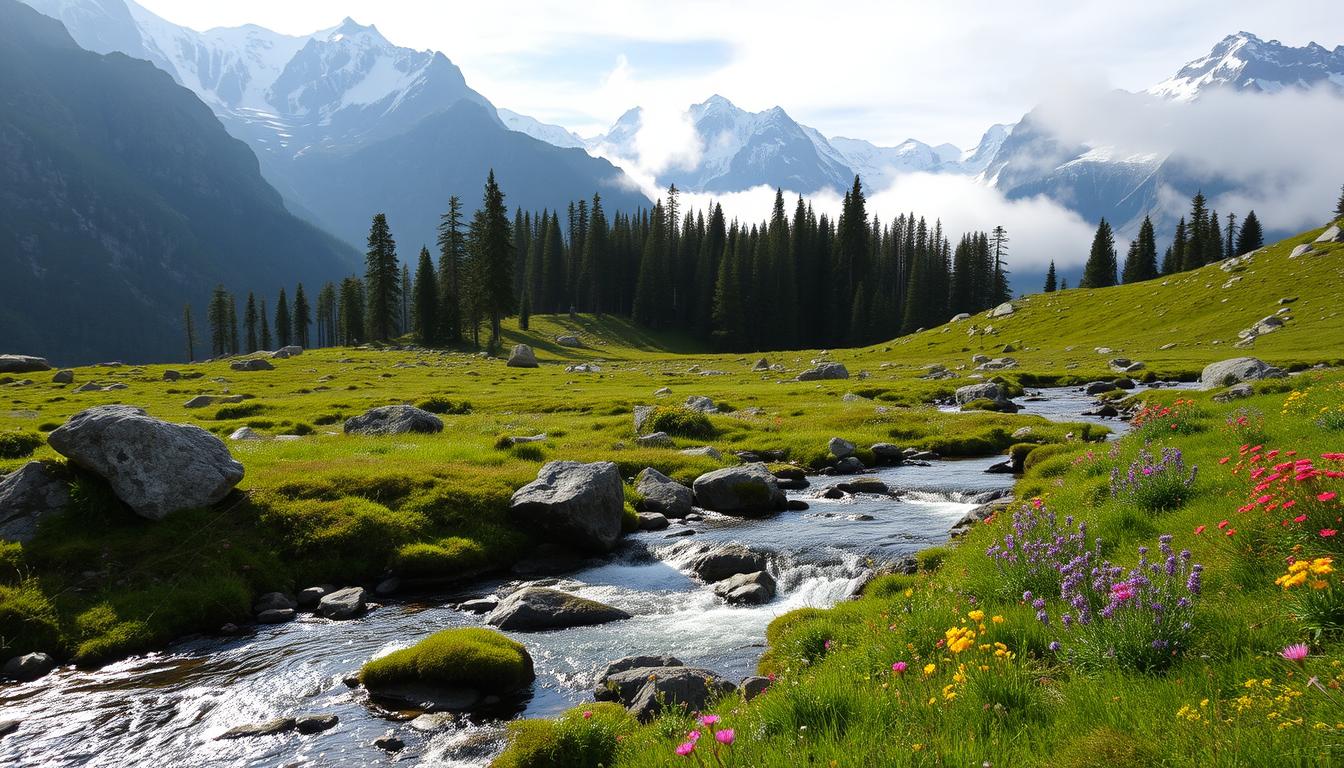
Iconic Landscapes to Prioritize: Cirques, Peaks, Lakes, and Waterfalls
Identify one cirque, one peak view, and one lake circuit to form a compact route. That simple choice keeps days achievable while still delivering the big scenery that draws people to this pyrenees national park.
Cirque de Gavarnie
Cirque de Gavarnie is pure drama: a rock amphitheater ringed by sixteen 3,000 m peaks and a 427 m waterfall. It’s easy to reach and unforgettable, ideal for an introductory day hike focused on landscapes and waterfalls.
Pique Longue du Vignemale
Pique Longue du Vignemale is the one highest summit in the French side, known for its glacier and striking north face. From Oulettes Gaube and the refuge des Oulettes de Gaube the peak looms above waterfalls and footbridges.
Pic du Midi d’Ossau and Ayous lakes
Pic du Midi d’Ossau (2,885 m) makes stunning reflections on the ayous lakes at sunrise. The pic midi silhouette is a photographer’s classic and a great reason to plan a short lake circuit.
Néouvielle Reserve
The Néouvielle Reserve offers granite massifs, hooked pines, and a dense network of small lakes. It feels otherworldly and rewards slow walking and quiet stops to soak in alpine scenes.
How to Explore Pyrenees National Park: Step-by-Step
Start by picking one town as your operational hub so you don’t waste time driving between trailheads. A clear base gives you options and helps shape a sensible route for the days ahead.
Choose your base
Choose your base: Cauterets, Gavarnie, or Ossau Valley
Pick a base with options in every direction. Cauterets suits Gaube Lake and the Chemin des Cascades. Gavarnie puts the cirque and Brèche close at hand. Ossau Valley opens lake circuits and Midi d’Ossau views.
Build a route: mixing GR®10 with HRP segments
Use GR®10 spines for clear lines and add HRP detours when weather allows. The HexaTrek section blends both philosophies and delivers top viewpoints without overcommitting.
Plan each day as a loop or shuttle so you can swap to a lower trail if storms roll in.
Book refuges vs. plan a bivouac near lakes
Book key refuge nights first to lock in rhythm. Refuges are high quality and save weight on food and gear.
If you want a wilder feel, consider legal bivouac sites near lakes and old shepherd huts. Always follow local rules and keep distance from water.
“Use the park houses in Cauterets and Gavarnie to check hut status and trail advisories before big days.”
- Keep daily elevation gain realistic — short miles can mean long hours.
- For families, mix short hikes with visitor-center stops or lift-access viewpoints.
- If car-based, go hub-and-spoke: one base, three to four day hikes, and one refuge night.
Top Trails and Routes for Every Experience Level
A smart route plan pairs a calm lake day with one higher, more exposed ridge. That balance helps you enjoy views without burning out.
Gaube Lake (Lac de Gaube) via Pont d’Espagne
Gaube Lake (Lac de Gaube) via Pont d’Espagne: moderate, scenic classic
The Gaube Lake trail is about 5 miles round-trip from Pont d’Espagne. Expect turquoise water, photogenic bridges, and Vignemale backdrops. It’s a great confidence builder for new hikers and families.
Cascades du Pont d’Espagne
Cascades du Pont d’Espagne: waterfall-hopping along Chemin des Cascades
The chemin des cascades route runs roughly 5 miles and links several falls: Escane-Gat, Pouey Bacou, and Ceriset. Watch footing on slick rock near spray and plan for extra photo stops.
Cirque de Gavarnie Trail
Cirque de Gavarnie Trail: hard, immersive cirque traverse
The cirque gavarnie trail is about 7.2 miles and climbs into towering walls. Start early for shade and fewer people. This one highest waterfall amphitheater rewards effort with nonstop drama.
GR®10 Pyrenean Way
GR®10 Pyrenean Way: the long-haul sampler of the French Pyrenees
The GR®10 totals about 551.5 miles across the French Pyrenees. For most visitors, pick sampler days—balcony segments give big vistas without committing to the full traverse.
| Route | Distance (approx) | Difficulty | Key Notes |
|---|---|---|---|
| Gaube Lake / Lac de Gaube | 5 miles RT | Moderate | Family-friendly; great views of Vignemale |
| Chemin des Cascades / Cascades du Pont d’Espagne | 5 miles | Easy–Moderate | Multiple waterfalls; slippery near spray |
| Cirque de Gavarnie | 7.2 miles | Hard | Immersive amphitheater; start early |
| GR®10 sampler days | Varies (segment) | Moderate–Hard | Choose balcony segments for views |
“Pack a light shell and expect quick mountain showers; pacing beats speed on these trails.”
- Pair gaube lake with a short Ossau side trip to see pic midi d’ossau at sunrise.
- Consider a water-themed day: chemin des cascades plus a cirque visit.
Sleeping in the Mountains: Refuges and Bivouac How-To
A night in a mountain refuge changes the whole trip—it adds comfort and local stories. Refuges mix simple comforts with raw scenery. They make long days easier and let you travel light on multi-day routes.

Refuge des Oulettes de Gaube
Refuge des Oulettes sits on a plateau with a stream and footbridges beneath Vignemale’s north face. The approach rewards you with glacier views and that cozy hut welcome after a steady climb.
Refuge de la Brèche de Roland (Les Sarradets)
Les Sarradets faces the famous brèche roland, a 100 m “door” to Spain. Sunrise light here is unforgettable and handy for crossing into Ordesa if you plan a border day.
Refuge d’Ayous & Refuge de Bastan
Ayous refuge sits by glassy ayous lakes; line up Pic Midi for mirror reflections at dawn. Bastan trades bustle for calm, with small dorms and easy access to Bastanet lakes.
- Book early in high season and bring a sleep sheet and earplugs.
- FFCAM membership gives big discounts for refuge des nights.
- Bivouac: pitch late, pack early, and keep clear of lake shores per park rules.
- Ask wardens about local hazards—rockfall from steep faces and routes to pique longue vignemale.
“Dinner and a shared bunk turn a hard day into a story you’ll tell for years.”
Nature and Wildlife Etiquette: Protecting a Living Heritage
Seeing a chamois or a golden eagle is a joy — done right, it leaves both you and the animal unharmed. Treat watching as a quiet activity. Use optics and patience rather than close approaches.
Spotting without stressing wildlife:
- Use binoculars for isards and marmots; if an animal stops feeding or alarms, you are too close.
- Keep voices low and step aside on narrow trails to lower stress for animals and fellow hikers.
- Never feed wildlife — human food harms health and changes behavior.
Protect sensitive flora and meadows:
- Stay on durable surfaces; edelweiss and Pyrenean violet need specific soils.
- Pack out microtrash like wrappers and tissue — wind moves tiny litter into remote basins.
- Teach kids to “leave what you find” — flowers, feathers, and rocks belong to the place.
Practical rules and local help
Early and late hours give the best chances to see raptors and mountain mammals near ridgelines. Avoid lingering at cliff edges during nesting season and use long lenses instead of drones.
“Visit a Park house to learn about seasonal closures and sensitive zones — your choices are part of the conservation toolkit.”
Respectful conduct protects landscapes and makes future visits better for everyone. When you hike with care, you help keep this place wild and welcoming.
Practical Logistics for the French Pyrenees
Simple travel choices make the mountains feel closer: pick a sensible airport and plan one shuttle or a short drive to your base town.
Getting there: access via Lourdes, Tarbes, and Cauterets
Fly into Lourdes/Tarbes and either rent a car or catch a shuttle to Cauterets or Gavarnie. Both towns put you near classic trailheads and park houses for last-minute intel.
Where to check in: national park houses are reachable from Lourdes, Tarbes, Arrens-Marsous, Luz-Saint-Sauveur, Gavarnie, and Cauterets.
Weather, altitude, and what to pack
Mountain weather flips fast. Carry a light waterproof, an insulating layer, hat, and gloves even on short walks to waterfalls.
Footwear matters: waterproof mid-boots with good grip keep you safe on the chemin des cascades and slick rock near des cascades.
Bring a paper map plus a charged phone with offline maps. Sun protection and extra water are musts at altitude.
Hot springs to unwind
After a long route, soak one evening at Ax-les-Thermes, Bagnères-de-Luchon, or Eaux-Chaudes for muscle recovery.
Shoulder-season travelers: check lifts, shuttles, and refuge openings before you go. Grocery resupply is easiest in base towns; confirm parking rules at busy trailheads to avoid long walks from overflow lots.
“Plan simply: a good arrival, reliable gear, and one soak will change your trip.”
Borderland Adventures: Linking to Ordesa and Monte Perdido
A single notch in the rock opens up an entirely different canyon world on the Spanish side. This corridor is one of the best ways to sample two protected landscapes in a single day.
Crossing the Brèche de Roland into Spain’s canyons
The Brèche de Roland is a 100 m natural doorway cut into a cliff face. Step through and you descend into Ordesa and Monte Perdido’s steep canyon country.
Expect changing trail surfaces: narrow French balcony paths give way to broader canyon tracks in border spain. Weather can shift over the crest, so carry layers and a reliable map or GPS.

Similar ecosystems across the border: forests, meadows, and wildlife
Flora and fauna mirror each other here. Scots pine and higher mountain pine stand above meadows dotted with edelweiss and bellflower.
- The brèche roland route is a true border experience — a rock gateway into canyon trails.
- Rules change in Spain: check bivouac and drone regulations before you cross.
- Navigation is straightforward in clear weather; fog in the notch can be disorienting.
- Consider a hut night on the French side, then loop into Spain and back for a bucket-list traverse.
“This corridor is part of a shared UNESCO World landscape—treat it like an open-air museum.”
Conclusion
End your route on a mellow note: swap a long ridge for a mirror lake and a warm refuge dinner.
Build your last day around one or two headliners—Cirque Gavarnie with its 427 m waterfall, Gaube Lake (the classic 5-mile via Pont d’Espagne), or the Ayous lakes below Pic Midi d’Ossau. A night at refuge des Oulettes or Ayous Refuge brings sunrise views and easy packing the next morning.
Keep it simple: pick one base town, map two to three trails, and save a flex day for weather or a spa dip. Treat the place kindly—stay on trail, respect wildlife, and leave no trace. With a little planning, the pyrenees national park will feel less like a visit and more like becoming part of the mountain landscape.